
Hurricane Lee threatens as potential Category 5 storm
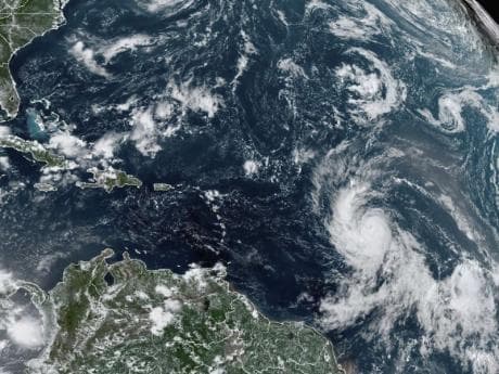
Hurricane Lee swirled through open waters, and is on course to possibly become the first Category 5 storm for this Atlantic season, according to forecasters.
While it is not anticipated to make landfall, its proximity to the northeast Caribbean is causing concern.
The storm’s latest statistics
Located about 965 miles from the northern Leeward Islands, Lee had wind speeds of up to 80 mph and was traveling in a west-northwest direction at 13 mph.
Its trajectory has the potential to bring tropical storm conditions to select islands, though meteorologists are still assessing the specific effects in terms of rainfall and wind gusts.
More on Hurricane Lee
Intensification on the forecast
By early Friday, forecasts indicate that Lee could morph into an “extremely dangerous” major hurricane.
The National Hurricane Center in Miami points to the cyclone’s surrounding environment as being conducive to rapid intensification.
This amplification will lead to life-threatening surf conditions reaching areas like the Lesser Antilles by Friday, extending to the British and US Virgin Islands, Puerto Rico, Hispaniola, the Bahamas, and Bermuda over the weekend.
Atlantic hurricane season in full swing
Lee is recognized as the 12th named storm for this year’s Atlantic hurricane season, which typically peaks during September and spans from June 1 to November 30.
Projections by the National Ocean and Atmospheric Administration from August suggest this season could see between 14 to 21 named storms, with up to 11 transforming into hurricanes. Major hurricanes could number between two to five.
Pacific's Category 5: Hurricane Jova
In a parallel development, the Pacific bears witness to Hurricane Jova.
While a potent Category 5 storm, it remains far from Mexico’s southwest coast, thus posing no immediate land threat.
Jova, located 535 miles southwest of Baja California’s southern tip, travels west-northwest at 16 mph with formidable wind speeds of 160 mph. However, this storm is set to begin its weakening phase by late Thursday.