


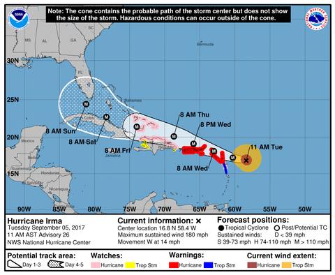
Hurricane Irma keeps getting stronger. At 5:00 am of Tuesday the hurricane recorded top wind speed of 150 MPH, but the 11:00 am report reported sustained winds topping 180 mph. According to the National Hurricane Center the hurricane could become the strongest Atlantic hurricane ever recorded outside the Gulf of Mexico and Caribbean.

At 11 a.m., Irma was located 225 miles east of Antigua, heading west at 14 mph. While wind speeds could fluctuate over the next day or two, forecasters say it will likely remain a very dangerous Cat 4 or 5 storm as it heads westward towards Puerto Rico, the Dominican Republic and Haiti, Cuba, the Bahamas and Florida.

The Florida Keys in danger
The current path places South Florida, particularly the Florida Keys in danger. According to the NHC tropical storm force winds could arrive at the Keys as early as Friday. Gov. Rick Scott has declared a state of emergency for all 67 Florida counties.
The storm is extremely large, and residents are urged not to focus on the exact path of the storms as hurricane force winds (over 75 MPH) extend 60 miles from its center and storm force winds (over 55 MPH) extends another 160 miles.

Impact of Florida dependent on turn
The impact of the storm on Florida is dependent on the directions its takes after passing Cuba. Currently, according to the NHC, a powerful high-pressure ridge is steering the storm westwards over the next four-five day. On Friday/Saturday, a trough moving across the U.S. mainland should begin weakening the western edge of the ridge, allowing Irma to turn northward. It is unknown where this turn will take place. Most of the forecast models have the turn directly over Florida from the Keys northward, but other models show an earlier turn skirting the state’s east coast, and another skirting the west coast.